Sky Map Visualizations and Credible Regions in Aladin
In this section, we demonstrate working with gravitational-wave sky localizations in Aladin Desktop. The following main topics are addressed.
MOC and GW Sky Localizations
The enclosed area within a given probability level contour of a GW sky map can be effectively described with a Multi-Order Coverage (MOC) map [1]. MOC is a standard of the Virtual Observatory which provides a representation of arbitrary regions on the unit sphere using the HEALPix sky tessellation.
The MOC data structure encodes irregular sky regions as a hierarchy of HEALPix
pixels. Each MOC cell is defined by two numbers: the hierarchy level (HEALPix
order=9 corresponds
to nside=512, and a resolution of
The MOC maps make database queries for retrieving objects and logical operation (such as union, intersection, subtraction, difference) extremely fast even for very complex sky regions.
MOC maps and multi-order sky maps are closely related. They use similar multi-resolution HEALPix data structures. The main distinction is that MOC maps encode regions on the sphere, whereas multi-order sky maps encode sampled images or functions on the sphere. The multi-order sky map FITS format is a superset of the MOC FITS format, the only difference being that a multi-order sky map has values attached to each cell (probability density, distance estimates) whereas a MOC map does not. Aladin version v12 supports the LIGO/Virgo/KAGRA multi-resolution sky maps.
Running Aladin Desktop
Aladin Desktop is a Java application. To run it, you must first have the Java Virtual Machine (JVM) installed. More details are in Aladin’s download page.
Note
Aladin may fail to load some LIGO/Virgo/KAGRA sky maps and display a
java.lang.OutOfMemoryError error message. This is because the highest
resolution LIGO/Virgo/KAGRA sky maps do not fit inside Aladin’s default
memory size.
You can increase the maximum memory size used by your Java runtime environment by following the instructions below.
Download the Aladin.jar from the Aladin download page. Execute it from a terminal by typing:
$ java -Xmx2g -jar Aladin.jar
The flag -Xmx<ammount of memory> specifies the maximum memory
allocation pool for a JVM. Here 2GB of memory is allocated. For GW sky
localizations with nside=2048, increase the memory allocated up to 3GB,
-Xmx3g.
Loading a GW Sky Localization
You can copy and paste the sky map URL from the GraceDB or drag and drop a
HEALPix FITS file from your operating system’s file browser in the main Aladin
window. Aladin v12 recognizes both the standard HEALPix format with the file
extension .fits.gz and the multi-resolution HEALPix format, distinguished
by the file extension .multiorder.fits. Better performances are achieved
with the multi-resolution format. Here we will work with the
LALInference sky map of GW170817.
Building a Credible Region
The sequence of the Aladin Desktop commands to create a credible region at a defined confidence level is described below. From the menu bar, select .
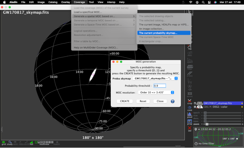
The MOC generation window has three options: the probability sky map, the threshold, and the MOC resolution. Make sure that the GW sky map that we loaded in the previous step is selected in the Proba skymap dropdown menu. Then enter a number between 0 and 1 for the credible level in the Probability threshold box. Finally, press the CREATE button. The MOC for the credible region is created and loaded in the Aladin Stack. If you repeat this process multiple times for different credible levels, then you can select each MOC independently from the Aladin stack.
Area Within a Credible Region
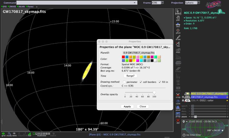
There are two ways to get the area within a MOC credible region. If you hover over the cursor over the MOC name in the Aladin stack, then the area in square degrees and the percentage of the sky are shown in the top-right corner of the Aladin window. Alternatively, you can right-click the MOC in the Aladin stack and select Properties from the contextual menu. The area and percentage of the sky are shown in the Properties dialog box. From this dialog box, you can also control the appearance and color of the MOC, which is useful for distinguishing multiple MOCs for different credible levels.
Querying and Filtering a Galaxy Catalog
Each gravitational-wave sky map for a CBC event provides a three-dimensional probability distribution as a function of sky position and distance [2]. Cross-matching that distribution with positions and redshifts of a galaxy catalog provides a filtered list of of possible host galaxies (see Distance and 3D Sky Maps). Aladin does not yet implement a galaxy catalog query by the three-dimensional posterior probability distribution. However, it is currently possible in Aladin to search for galaxies within the 2D credible region on the sky and, afterwards, apply a distance cut that it independent of sky position.
Here we query the galaxies collected in the GLADE catalog inside the 90% credible region of GW170817. Then we filter those galaxies according to the marginal distance posterior distribution integrated over the whole sky.
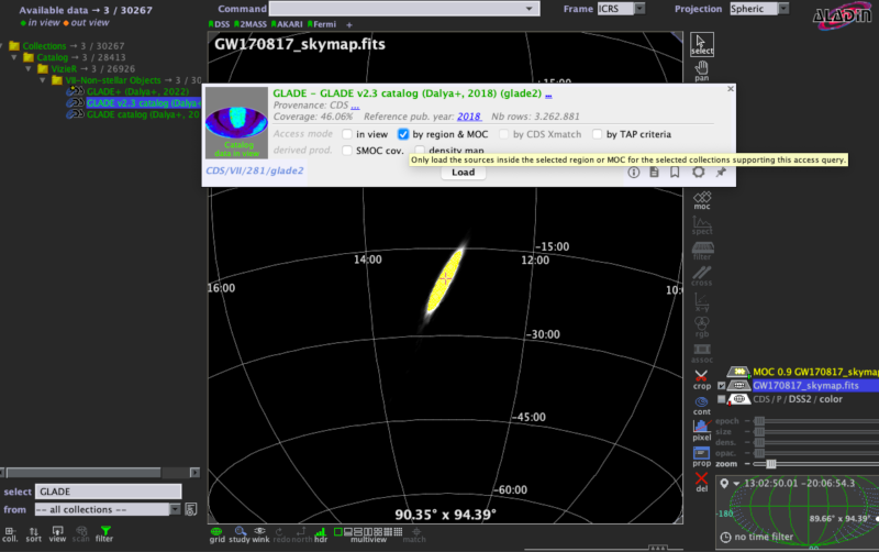
Pick out the galaxy catalog from the data collections tree.
Any of the 20,000 catalogs published in the Virtual Observatory can be retrieved from the data collections tree in the left panel of the main Aladin window.
To find the GLADE catalog, make sure that is selected in the from dropdown menu in the bottom of the left panel, then type
GLADEin the select text field. In the data collections tree, click on .Load the galaxy catalog filtered by the 2D credible region.
In the popup window, click the by region & MOC checkbox in order to filter it by the 2D credible region that we created earlier. Then press the Load button.
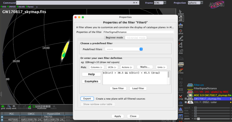
Filter the galaxy catalog by distance.
The posterior mean distance and the posterior standard deviation of luminosity distance in Mpc are reported in the FITS file header with the keywords
DISTMEANandDISTSTD, respectively. In the case of GW170817, they have the valuesDISTMEAN = 38.0andDISTSTD = 7.5.Select from the menu bar. This opens the Properties dialog box contains two tabs. Select the Advanced mode tab and copy the following text into the filter definition box:
${Dist} > 30.5 && ${Dist} < 45.5 {draw}This is an expression for a 1-sigma cut on distance in the Aladin filter syntax.
Distis the column in the GLADE catalog corresponding to the distance in Mpc.Click on Apply and then on Export to create a new level in the Aladin stack consisting only of sources selected by the filter.
Thumbnail View Generator
Finally, we make a mosaic of the filtered galaxies. Here the thumbnails are color composition images of the Digitized Sky Surveys (DSS).
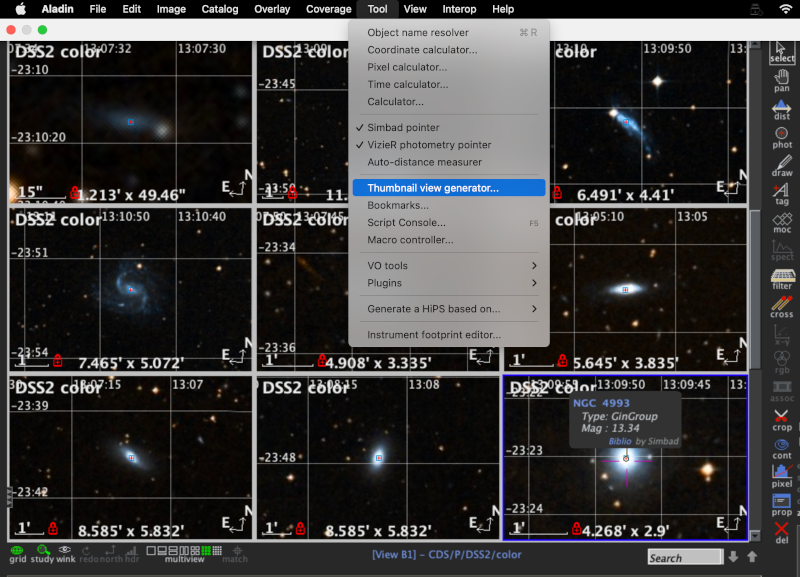
To get this, we load the DSS colored survey from the data collections tree. Then select from the menu bar, and click the Ok button in the dialog box. Aladin will generate thumbnail views from the current image in the main window. To change it, check the corresponding plan in the Aladin stack.
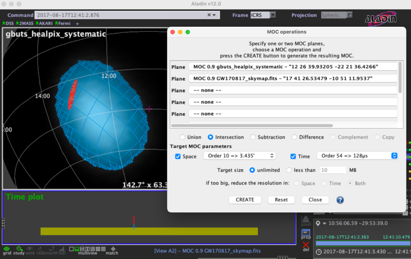
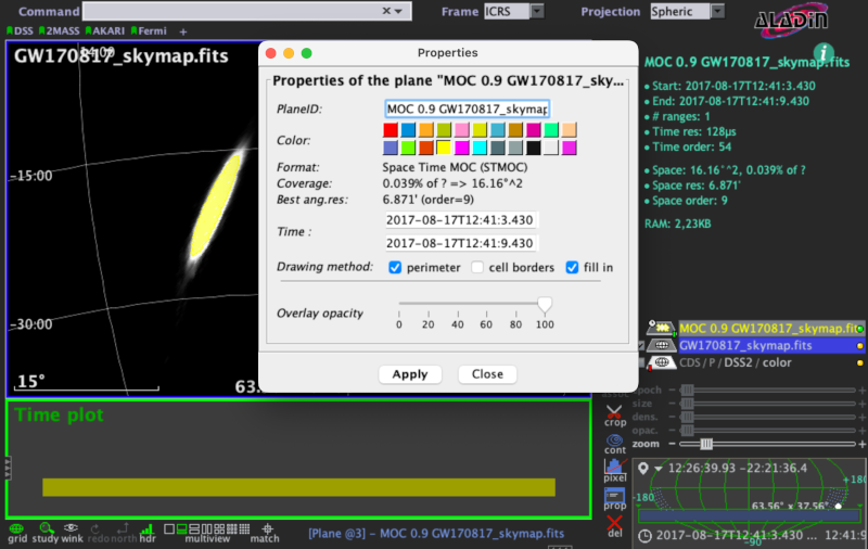
Building a Spatial and Temporal Credible Region
Aladin v12 offers the functionality to add temporal information in any spatial coverage described by the MOC data structure. The resulting new data structure is indicated with STMOC (Space and Time MOC) [3].
Click on the name of the plan corresponding to the credible region.
MOC 0.9 GW170817_skymap.fits will appear highlighted.
From the menu bar, press
.
The Properties is equipped with the Time section with
two boxes in which you can select a time interval.
The merge time of GW170817 occurs at 2017-08-17T12:41:04.43 UTC.
Searching for coincident with external triggers, we apply a time window
from -1 s to 5 s around the GW time i.e., from
2017-08-17T12:41:03.43 UTC to 2017-08-17T12:41:09.43 UTC.
Click on Apply to create a credible region with this time range. The main Aladin window shows a bottom box Time plot displaying the associated time line.
Spatial and Temporal Coverage Intersections
The STMOC data structure allows you to perform operations in space and time simultaneously. We build a new STMOC with the error box of GRB 170817 provided by the GBM instrument on board the Fermi satellite. GRB170817 occurred at 2017-08-17T12:41:06 UTC [4].
The intersection is performed by opening the window Logical operations from . An additional MOC layer is loaded into the Aladin stack with information on the spatial and temporal coincident of the two astrophysical events.